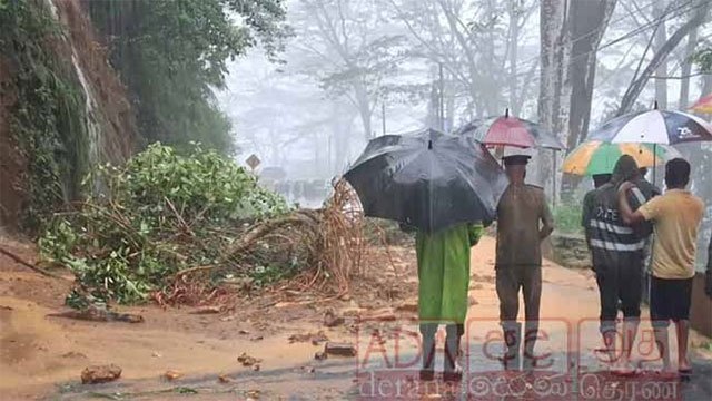
Main roads across Sri Lanka’s central hills were closed or blocked on Monday and homes were flooded in Hatton and Ratnapura, as a sustained wet spell delivered more than 200 mm of rain to parts of the Nuwara Eliya district in 24 hours.
The disruption ran along the same upland belt now under the country’s highest-tier landslide and flood warnings.
Colombo–Kandy road closed at Kadugannawa
Police temporarily closed the Colombo–Kandy main road between Kadugannawa and Ganethenna because of the risk of rocks falling onto the carriageway, and told motorists to use alternative routes until further notice.
The closure cuts the principal route between the commercial capital and Kandy. Police said the decision was taken for the safety of drivers and passengers given the weather, and asked drivers to follow traffic instructions and stay off the affected stretch until it is declared safe.
Hatton–Colombo road at a standstill
Vehicle traffic on the Hatton–Colombo main road came to a complete standstill after earth slips at several points in the Diyagala area, police said.
Earth and boulders fell onto the road, halting movement in both directions — traffic from Hatton towards Ginigathena, Nawalapitiya, Kandy and Colombo, and traffic heading the other way towards Hatton. Long queues of vehicles built up on both sides. The Road Development Authority is clearing the debris.
Norwood Executive Engineer A.M. Sadiq later put the damage on that stretch at five major earth slips at different points along the main road between Hatton and Ginigathhena, caused by the heavy rain over the western slopes of the central hills in the past three days. Clearing work began during the day but was severely hampered by the rain still falling, he said. Police told drivers using the road to proceed with care.
Gampola–Hemmathagama road slips at two points
The Gampola–Hemmathagama road via Ambuluwawa slipped at two separate locations during the day, Hiru News reported.
Road Development Authority officers began clearing the fallen earth on Monday afternoon and reopened a single lane to traffic. Police asked the public to stay away from the area and use alternative routes given the continuing risk of further slips.
The same road was cut at several points during Cyclone Ditwah, when repairs took more than two months.
Nawalapitiya–Ginigathhena road closed at Walapitiya
The Nawalapitiya–Ginigathhena road was closed temporarily at Walapitiya on Monday evening because of a risk of the ground subsiding, the Nawalapitiya Divisional Secretary said, according to Hiru News.
Landslide damages Watawala Railway Station
A landslide severely damaged the Watawala Railway Station after an earth embankment behind it collapsed at about 2.00 p.m. on Monday, Ada Derana reported. Watawala Police said a railway employee who was on the station premises at the time suffered minor injuries.
Police also launched a search for a person from Watawala who was swept away by strong currents after the Hatton Oya overflowed. The Nuwara Eliya district authorities reported six people missing as of 4.00 p.m., two of them carried off by flood water in the Ambagamuwa area, which contains Watawala.
Watawala recorded the country’s heaviest rainfall in the 24 hours to Monday morning, at 204 mm.
Dik Oya bursts its banks
Several houses along both banks of the Dik Oya were inundated after the stream, which carries water from Hatton down to the Castlereagh Reservoir, overflowed.
Residents said the same thing happened in 2013, when the Dik Oya last burst its banks and flooded the same properties.
A tourist hotel in the Nawalapitiya area was also flooded after the Mahaweli River overflowed.
Kelani tributary submerges a bridge at Yatiyantota
Traffic on the Yatiyantota–Bulathkohupitiya road stopped completely after the Parussella embankment bridge went entirely under water, Hiru News reported. Its correspondent attributed the flooding to the Wee Oya overflowing as the Kelani River level rose rapidly. Several houses in the Parussella area are under threat of flooding.
Kalu Ganga reaches flood level at Ratnapura
In the Ratnapura district, the Kalu Ganga has risen to its six-foot flood threshold at the Pulugupitiya gauge, according to Hiru News correspondents.
Low-lying land in the Mudduwa and Ethoya areas of the Ratnapura Divisional Secretariat division is under water. The Ratnapura–Alupotha main road is submerged at Ethoya, badly disrupting local traffic, and the Mudduwa public cemetery and surrounding low ground have also flooded, leaving several houses at risk. Heavy rain was still falling intermittently over Ratnapura.
Where the rain fell
Rainfall above 100 mm was recorded at numerous locations in the 24 hours to 6.00 a.m. on Monday. The highest was 204 mm at Watawala in the Nuwara Eliya district, followed by Norton at 187.8 mm.
Other stations over the threshold were Dolosbage at 172.0 mm and Nawalapitiya at 153.4 mm in the Kandy district; Hatton 148.4 mm, Hunugalaoya 137.8 mm, Kotagala 137.0 mm and Nanu Oya 131.6 mm in Nuwara Eliya; Kitulgala at 140.8 mm in Kegalle; and Wewelwatta 112.4 mm and Walaboda 101.2 mm in Ratnapura.
Under two escalating warnings
Every location listed above sits inside an area already under an active alert. The National Building Research Organisation escalated its landslide warnings twice on Monday morning, ending with Red evacuation alerts for six divisions in Kandy, Kegalle and Nuwara Eliya — among them Yatiyantota, where the Parussella bridge went under.
At 1.00 p.m. the Irrigation Department issued a Red major-flood alert for ten divisions along the Mahaweli, valid for 48 hours, citing the risk that spill gates at the Kotmale Reservoir will have to be opened. Three gates at the Upper Kotmale Reservoir had already opened automatically overnight.
The Met Department’s Monday forecast puts further falls above 100 mm over Sabaragamuwa and the Kandy and Nuwara Eliya districts, and principals in the Hatton and Nuwara Eliya education zones were given discretion to close schools for the day.