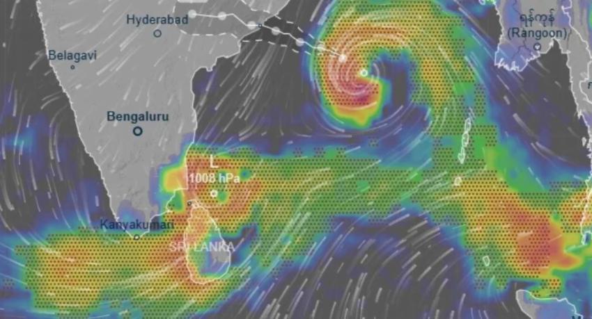
Cyclone Arnab has reached very severe cyclonic storm strength over the west-central Bay of Bengal, several hours earlier than India’s own forecast projected, and is due to cross the Andhra Pradesh coast on Wednesday forenoon with sustained winds of 115–125 kmph gusting to 140 kmph.
The India Meteorological Department, which names storms in this basin, classified the system as a very severe cyclonic storm in National Bulletin No. 15, issued on Tuesday. At 2.30 a.m. Indian time the storm was centred near 15.9°N, 85.4°E — about 300 km south-east of Visakhapatnam and 530 km east of Bapatla — moving west-north-west at 25 kmph.
It is forecast to hold that track until Tuesday evening, then turn north-west and cross the Andhra Pradesh and Yanam coasts between Bapatla and Visakhapatnam, close to Yanam, by the forenoon of 28 October. The system is under continuous watch by the Doppler weather radar at Visakhapatnam.
It is running ahead of the forecast issued 21 hours earlier
The escalation has outpaced IMD’s own projection. Bulletin No. 8, issued on Monday morning, put the storm at severe cyclonic storm strength at 5.30 a.m. on Tuesday, with winds of 110–120 kmph, and did not expect the very severe stage until Tuesday evening.
| 5.30 a.m. Tuesday | Forecast (Mon, Bulletin 8) | Actual (Tue, Bulletin 15) |
|---|---|---|
| Category | Severe Cyclonic Storm | Very Severe Cyclonic Storm |
| Sustained wind | 110–120 kmph | 130–140 kmph |
| Gusts | 130 kmph | 155 kmph |
Arnab is therefore both a category ahead of schedule and about 20 kmph stronger than projected a day earlier. Bulletin 15 now puts its peak at 135–145 kmph gusting to 160 kmph through Tuesday — above the 115–125 kmph peak Monday’s bulletin had forecast.
After landfall the decay is expected to be rapid: back to a cyclonic storm by late Wednesday, a deep depression on Thursday, and a well-marked low by Friday.
Three Sri Lankan outlets had the timetable; one did not
The Department of Meteorology’s accounts, as reported in Colombo on Monday, match what has happened. The Daily Mirror reported that the storm would reach severe strength by Monday evening and very severe on 27 October, with landfall around 11.30 a.m. on 28 October — all three now borne out. NewsFirst reported at midday on Monday that Arnab could become a severe cyclonic storm by about 11.30 p.m. that night, which is consistent with IMD’s “by midnight of the 26th”.
Hiru News carried a different timetable, placing the severe stage on Tuesday and the very severe stage on Wednesday the 28th — a day late at both steps. This desk recorded that one-day gap as an open discrepancy on Monday night, having been unable to read IMD’s forecast table at the time. The bulletins settle it against Hiru. The storm was already very severe by 2.30 a.m. on Tuesday.
What it means for Sri Lanka
The storm is moving away from the island, and no filing forecasts a direct hit. The Daily Mirror’s account says showery weather will continue over the south-western parts of the island for several days on the storm’s wind patterns, with showers or thundershowers in the Northern, Western, Sabaragamuwa, Southern, North-Western, Central and North-Central provinces and the Trincomalee district, and falls exceeding 75 mm at some locations.
The marine risk is the sharper one. NewsFirst reported winds of 80–100 kmph and wave heights of three to four metres in the affected sea areas, with fishermen told to move vessels to safety immediately. A red warning for strong winds and very rough seas, issued at 8 p.m. on Monday for 12 hours, is covered with the full no-go coordinates in this desk’s running report on the weather spell, which also carries the Sri Lankan casualty and displacement figures.
IMD’s heaviest warnings fall on India: extremely heavy rainfall of 21 cm or more at isolated places over coastal Andhra Pradesh on Tuesday and Wednesday, with south Odisha under the same category on Wednesday.
Update, 27 October: Colombo confirms the very severe classification
The Department of Meteorology issued its own statement on Tuesday morning confirming that Arnab has intensified into a very severe cyclonic storm, and both the Daily Mirror (6.17 a.m.) and Hiru News (6.26 a.m.) carried it. This closes the gap recorded below: the Sri Lankan filings have now caught up with the bulletins.
The department’s fix matches IMD’s exactly — 2.30 a.m., 15.9°N and 85.4°E — and locates it for a Sri Lankan reader as about 890 km north-east of Kankesanthurai. It expects the storm to track west-north-west until 5.30 p.m. on Tuesday before turning north-west, and to cross the Indian coast through Andhra Pradesh still at very severe strength by 11.30 a.m. on Wednesday, matching the IMD landfall window.
For the island, the department repeats that there will be no direct impact, but that the wind flow drawn towards the system keeps rain over the south-west. Expected on Tuesday:
- Showers or thundershowers at times in the Western, Sabaragamuwa, Southern and North-Western provinces and the Kandy and Nuwara Eliya districts, with falls exceeding 75 mm at some locations.
- Showers or thundershowers at a few places in the Eastern Province after 1 p.m.
- Strong winds of 40–50 kmph at times over the western slopes of the central hills, the Northern, North-Central and North-Western provinces and the Trincomalee and Hambantota districts — reported by the Daily Mirror and not carried in Hiru’s account.
One note on Hiru’s filing: its English headline calls Arnab a “severe cyclonic storm”, but its Sinhala text says ඉතා ප්රබල සුළි කුණාටුවක් — very severe — which is the correct category and matches the department, the Daily Mirror and IMD. The headline understates it by one stage.
Both filings are from newsrooms already cited here, so they add provenance rather than a further credibility step.
Update, 27 October: India opens its waters to 25 Sri Lankan boats
The question of whether any Sri Lankan fishing fleet was inside the warned sea area — recorded as unanswered below — has been answered, and the answer involved a diplomatic approach to New Delhi.
Around 25 Sri Lankan multi-day fishing vessels stranded near Indian waters have been granted permission to enter Indian territorial waters and shelter there from the storm, the Daily Mirror reported on Tuesday morning.
The permission followed intervention by the Ministry of Fisheries, Aquatic and Marine Resources, which made a formal request to the Indian government through the High Commission of India in Sri Lanka. Crews have been instructed to leave the high-risk areas immediately and make for designated safe locations, and the Department of Fisheries and Aquatic Resources has notified vessel owners of the safety procedures to follow.
The permission is notable in itself: the maritime boundary between the two countries is the subject of a long-running and frequently contentious fisheries dispute, and Indian waters are not ordinarily open to Sri Lankan multi-day craft.
The same filing carries the Department of Meteorology’s advisory of 27 October, which puts landfall on the Andhra Pradesh coast by 28 October — consistent with the IMD timetable above. It warns that winds in sea areas between latitudes 10°N and 20°N and longitudes 80°E and 95°E could reach 80–140 kmph, with wave heights of three to four metres, and advises fishing communities to stay out of the affected deep-sea areas.
Update, Tuesday evening: the Met Department puts the easing at Wednesday, and fixes landfall at 11.30 a.m.
The question recorded below as unanswered — whether the storm’s early escalation changes the outlook beyond Tuesday — has now been answered directly. The Department of Meteorology says the impact of Arnab on weather across Sri Lanka is expected to gradually decrease from Wednesday, the Daily Mirror reported at 5.29 p.m. on Tuesday.
The same advisory supplies a position fix and a landfall time more precise than anything above:
- At 11.30 a.m. on 27 October the storm was centred near latitude 16.2°N, longitude 83.7°E — about 800 km north-east of Kankesanthurai.
- It is expected to cross the Indian coast through Andhra Pradesh as a very severe cyclonic storm at around 11.30 a.m. on Wednesday.
That hour sits inside the “forenoon” window IMD’s bulletin gave, so the Colombo and New Delhi timetables agree, and the department is still carrying the very severe classification at landfall rather than a weakening one.
For Tuesday itself the department forecast several spells of showers in the Western and Sabaragamuwa provinces and the Kandy, Nuwara Eliya, Galle and Matara districts, with showers or thundershowers at a few places in the Uva Province and the Batticaloa and Ampara districts after 1.00 p.m. Strong winds of 40–50 kmph were expected at times over the western slopes of the central hills, the Northern, North-Central and North-Western provinces and the Trincomalee and Hambantota districts — the same wind figures and areas carried in the morning advisory, unchanged through the day. The public was advised to guard against damage from localised strong winds and lightning.
The Daily Mirror is already cited here, so this adds provenance and closes a flagged gap rather than lifting the credibility rating.
Update, late Tuesday: a sharply escalated marine advisory — and a landfall window that does not match
A further Department of Meteorology advisory, carried by Hiru News at 11.21 p.m. on Tuesday, raises the marine warning substantially above the figures recorded earlier on this page.
- Winds in the advisory sea areas may rise to 80–150 kmph — above the 80–140 kmph given in the morning advisory.
- Wave heights of 6.0 to 9.0 metres, with thundershowers. The earlier advisories on this page gave three to four metres. This is roughly double.
- The no-go box is given as latitudes 10°N–20°N and longitudes 80°E–90°E. The morning advisory gave the eastern limit as 95°E; this one narrows it to 90°E.
- Deep and shallow sea areas from Puttalam through Kankesanthurai to Mullaitivu, and from Galle through Hambantota to Pottuvil, may be very rough at times; other sea areas around the island rough at times.
- Off the coast from Matara through Hambantota to Pottuvil, waves may reach 2.0–2.5 metres.
Fishing and naval communities are told to stay out of the warned box and to sail for safe areas.
The landfall hour is now in dispute
Hiru’s account of this advisory places the storm’s arrival between 2.00 a.m. and 4.00 a.m. on Wednesday the 28th, crossing Andhra Pradesh still as a very severe cyclonic storm.
That does not match either timetable already on this page. The Department of Meteorology’s own 5.29 p.m. advisory, as carried by the Daily Mirror, put landfall at around 11.30 a.m. on Wednesday, and IMD’s Bulletin No. 15 put it in the forenoon of the 28th. A 2–4 a.m. crossing is neither.
This desk is not resolving the conflict in favour of the later filing. The brain of this operation records repeated cases of Hiru’s English rendering altering a time, a tense or a category that its own source did not; it also records cases where Hiru correctly transcribed a foreign-authority detail that other outlets dropped. Both are possible here. What can be said is that the position fix in the same filing is internally consistent with the rest: Arnab centred about 800 km north-east of Kankesanthurai, which is the same distance the Daily Mirror’s advisory gave — though Hiru timestamps that fix at 2.30 p.m. where the Daily Mirror gave 11.30 a.m.
Readers planning around the storm should treat the forenoon of Wednesday as the official window, since that is what both IMD and the Department of Meteorology’s attributed advisories state, and treat the 2–4 a.m. figure as unconfirmed pending a second filing.
Hiru News is already cited here, so this adds provenance and an escalated marine warning rather than a further credibility step.
Tuesday’s highest recorded temperature
For the record, the highest temperature reported anywhere in Sri Lanka on 27 October was 33.1°C, at the Polonnaruwa Meteorological Station, recorded during the afternoon, the Daily Mirror reported at 7.11 p.m. citing the Department of Meteorology, which publishes a daily map of station maxima.
This desk draws no inference from the figure. It is recorded here because it is the department’s own reading for the day the cyclone was closest to the island, and the filing offers no comparison with seasonal norms or with the preceding days.
Not reported
Whether the 6–9 metre wave forecast and the 80–150 kmph wind figure supersede the morning advisory’s lower numbers, or describe a different part of the warned area, is not stated. No filing explains why the eastern limit of the no-go box moved from 95°E to 90°E, or why the landfall hour differs by some seven to nine hours between filings of the same day.
IMD’s bulletin is a cyclone warning for Andhra Pradesh and the adjoining south Odisha coasts and carries no forecast for Sri Lanka. None of the filings says whether the red warning for rough seas issued on Monday night has been extended past its 12-hour window. Tuesday evening’s advisory says the impact will “gradually” decrease from Wednesday but does not say when it is expected to clear, or whether the reservoir and landslide warnings now in force are expected to ease with it.
On the sheltering vessels, the filing does not say where the boats were granted shelter, how many crew are aboard the 25 vessels, how long the permission lasts, or what arrangements govern their return. It does not say whether any Sri Lankan vessels remain unaccounted for in the warned area, or whether the request covered a larger number than the 25 granted.
The India Meteorological Department is cited here as the originating authority for the storm’s classification and track. It is not one of this site’s verified newsrooms, and the credibility rating above reflects only the three Sri Lankan outlets.
Update, 28 October — Arnab is crossing the coast, and the forecast window held
Cyclone Arnab has begun crossing onto land over the Andhra Pradesh and Yanam coasts, bringing torrential rain, with sustained winds of 125–135 kmph gusting to 150 kmph.
Hiru News reported at 7.32 a.m. Colombo time on Wednesday that the storm had started to move inland, citing the India Meteorological Department.
The forecast this article was testing
This article’s central finding was that Arnab outran IMD’s own forecast — Bulletin No. 8 projected severe cyclonic storm strength and 110–120 kmph at a point when Bulletin No. 15 recorded very severe strength and 130–140 kmph gusting 155.
On the landfall itself, the forecast held. Bulletin No. 15 put the crossing between Bapatla and Visakhapatnam, close to Yanam, by the forenoon of 28 October. The storm is crossing the Andhra Pradesh and Yanam coasts on the forenoon of 28 October. The location and the timing are both as issued.
The intensity at landfall is the part that did not come down. Bulletin No. 15 forecast sustained winds of 115–125 kmph gusting to 140 at the crossing; the IMD figures Hiru carries at the coast are 125–135 kmph gusting to 150 — roughly 10 kmph higher on both measures. The storm arrived at the right place at the right hour, slightly stronger than the track said it would be.
That is consistent with the pattern recorded above rather than a new discrepancy: IMD’s positional forecasting for this system has been accurate throughout, and its intensity forecasting has run a step behind the storm.
Sri Lanka’s side: the impact is easing
The Department of Meteorology said on Wednesday morning that the effect on Sri Lankan weather from the storm — now making landfall in India — is gradually decreasing, Hiru News reported at 6.07 a.m.
That confirms the Daily Mirror’s Tuesday advisory, cited above, that the impact would ease from Wednesday. The department’s forecast for the day:
| Area | Expected |
|---|---|
| Western and Sabaragamuwa provinces; Kandy, Nuwara Eliya, Galle and Matara districts | Several showers |
| Uva province; Batticaloa and Ampara districts | Showers or thundershowers after 1 p.m. |
| Western slopes of the central hills; Northern, North Central and North Western provinces; Trincomalee and Hambantota districts | Strong winds of 40–50 kmph at times |
The department asked the public to take steps to minimise damage from the temporary strong winds and lightning that can accompany thundershowers.
A caution on reading “easing”
Rain easing is not the same as the water receding. The rainfall of the past several days is still working through the catchments: two of Victoria Reservoir’s automatic spill gates opened on Tuesday evening, releasing 150 cubic metres a second into the Mahaweli, and landslide and minor flood warnings issued during the spell remain a separate matter from the forecast.
40–50 kmph winds across seven districts and the western slopes are also still being forecast on the day the department describes the impact as decreasing.
Still not reported
No filing reports damage, casualties or evacuations on the Indian side, and neither Hiru report gives a figure for rainfall already recorded in Sri Lanka during the spell. Neither says when the island’s weather is expected to return to normal, whether the red warning for rough seas has been withdrawn, or what has become of the 25 Sri Lankan fishing boats granted shelter in Indian waters.
Neither the Daily Mirror nor NewsFirst had filed on the landfall at the time of this update.
Update, Wednesday evening: landfall complete, and the wind forecast is revised down
The Department of Meteorology now says Arnab has entered land from the Andhra Pradesh coast, and that the system’s effect on Sri Lankan weather is accordingly decreasing, Hiru News reported at 5.09 p.m. Colombo time.
That is the completed form of the morning’s report, which had the storm beginning to cross. The forecast areas are unchanged from the table above — several spells of rain in the Western and Sabaragamuwa provinces and the Kandy, Nuwara Eliya, Galle and Matara districts, and showers or thundershowers after 1 p.m. in Uva Province and the Batticaloa and Ampara districts.
One figure has moved. The strong-wind forecast for the western slopes of the central hills, the Northern, North-Central and North-Western provinces and the Trincomalee and Hambantota districts is now 30–40 kmph, down from the 40–50 kmph carried in every advisory on this page since Tuesday morning. The affected areas are identical; only the speed band has been lowered.
That is the first quantified sign of the easing the department has been forecasting since Tuesday, and it is consistent with a system that is now inland over India. The public is still advised to take precautions against thundershowers and lightning, and the caution recorded above still applies: easing rain is not the same as receding water.
A third spelling of the storm’s name
Hiru renders the name in Sinhala as ඔනර්බ් — “Onarb” — and glosses it in the same sentence, in English, as “(Aab)”. Neither matches Arnab, the name used by the India Meteorological Department, which is the authority that names storms in this basin and whose bulletins are cited at the top of this article. Hiru’s own earlier URLs on this storm used “Ornab” as well as “Onarb”.
This site uses Arnab throughout, on IMD’s authority. The variants are recorded here only so that readers searching for Hiru’s coverage can find it.
Hiru News is already cited on this page, so this update adds provenance and a revised figure rather than a further credibility step.
Update, 29 October — Arnab is down to a deep depression, and the deep-sea warning has been withdrawn
The storm has weakened to a deep depression, and the Department of Meteorology has lifted the warning that kept multi-day fishing boats and naval craft out of the deep-sea areas of the Bay of Bengal. Hiru News reported the department’s statement at 6.17 a.m. Colombo time on Thursday.
This closes the question recorded twice below — whether the warning for rough seas had been withdrawn. It has.
The decay is running to schedule
The department expects the system, still moving roughly northward, to weaken further:
| Stage | Expected |
|---|---|
| Deep depression | Now |
| Depression | By Thursday morning |
| Low pressure area | By 5.30 p.m. Thursday |
That matches the decay sequence IMD’s Bulletin No. 15 set out at the top of this article — cyclonic storm by late Wednesday, deep depression Thursday, well-marked low by Friday — with the Colombo advisory running, if anything, slightly ahead of it. The system’s effect on the deep-sea areas of the Bay of Bengal will decrease gradually through Thursday.
What replaces the warning
The lifting of the deep-sea warning is not a forecast of calm water. The department’s same statement keeps a reduced set of marine conditions in place:
- Showers or thundershowers at times in the sea areas around the island.
- Winds from the south-west at 25–35 kmph.
- In the deep and shallow sea areas from Puttalam through Kankesanthurai to Mullaitivu, and from Galle through Hambantota to Pottuvil, winds may rise at times to 45 kmph and those areas may be fairly rough.
- During thundershowers, winds in those areas may temporarily reach 60–70 kmph, making the sea temporarily very rough.
Set against the advisory recorded above from late Tuesday — 80–150 kmph winds, waves of 6 to 9 metres, and a no-go box between 10°N–20°N and 80°E–90°E — this is a substantial step down. The wind ceiling has fallen from 150 kmph to 45 kmph outside thunderstorms, and the prohibition on sailing has gone.
Still not reported
The statement gives no wave heights to replace the 6–9 metre figure, and does not say whether the red warning issued on Monday night was formally withdrawn at an earlier point or simply expired. It does not say what has become of the 25 Sri Lankan fishing boats granted shelter in Indian waters, or whether they have returned — a gap now open since Tuesday. No filing reports damage, casualties or evacuations on the Indian side.
On the name again. This filing’s structured data renders the storm as ඔර්නබ් (Arnab), where the visible text of the same page gives (Aab) — the two spellings recorded above now appear on a single Hiru page. This site continues to use Arnab.
Hiru News is already cited here, so this update closes a flagged gap rather than lifting the credibility rating.
Update — 29 October, 10.30 p.m.
The Indian-side gap flagged above is now closed. Arnab made landfall in southeastern Andhra Pradesh in the early hours of Wednesday 28 October, and casualty and damage figures began appearing on Thursday — though they do not agree. Andhra Pradesh officials put the toll at six, the Times of India at nine, and Al Jazeera’s same-day aftermath coverage still carried three. Chief Minister N. Chandrababu Naidu reported 15,000 electricity poles down, with power restored everywhere except Konaseema and West Godavari.
This desk has set out the three competing tolls and the evacuation figures in a separate article: Cyclone Arnab’s death toll is being reported three different ways a day after landfall.
The other gaps flagged above remain open: no filing has given replacement wave heights, said whether Monday night’s red warning was formally withdrawn, or reported what became of the 25 Sri Lankan fishing boats granted shelter in Indian waters.